[ Republishing – this article was first posted Nov 8, 2016 ]
![]() Sun Seeker Pro is a macOS app that projects solar path, solar energy, sunlight exposure and other solar related information onto Photo Sphere images or other user-supplied images such as site plan or overhead architectural schemas, and performs various types of analyses on this data, including auto-generated shade data.
Sun Seeker Pro is a macOS app that projects solar path, solar energy, sunlight exposure and other solar related information onto Photo Sphere images or other user-supplied images such as site plan or overhead architectural schemas, and performs various types of analyses on this data, including auto-generated shade data.
Some things you can do with this app:
- Visualise the annual solar path over photo imagery
- Visualise solar direction for all hours, all seasons on on overhead satellite view, or site plan
- Auto-generate shade silhouette data directly from the Photo Sphere
- Get reports of sunlight exposure periods (taking into account shaded areas)
- Get detailed reports of solar energy availability, based on selectable panel characteristics (taking into account shaded areas)
The app contains a couple of demo locations for you to play with. You can open these to view them by choosing Location / Open from the app’s menu or Location button. The demo projects already contain Photo Sphere images, which may be panned and zoomed in the 3D view.
However, when creating a new location project for your own chosen locations, typically you will first want to obtain a Photo Sphere image for that location. This might be a site at which you intend to shoot a movie scene, a location (roof) on which you want to install solar panels, the centre of a window in your house for which you want to find annual sunshine hours, a site for a tennis court for finding best playing hours, a location at which you intend to take a photo of a sunrise or sunset, the location of a tree or plant whose solar exposure you want to examine, etc.
Note that you can use the app without a Photo Sphere, simply by searching or browsing for any address or map location. However, the most powerful features of the app (especially when using shade data) rely on having a Photo Sphere for the location in question.
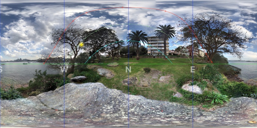
Photo Sphere images, which are also known as spherical photos, or 360deg photos, can be taken with Google’s free “Street View” app, available on both iOS and Android. You use this app to take a series of photos which cover the entire sphere, around, above and below where you stand. The app automatically merges the photos (also known as “stitching”) into one large rectangular area that is a linear representation of the entire spherical view. You can export any Photo Spheres you take and use them to open a new location project in the Sun Seeker Pro app.
Photo Spheres may also be taken in a single shot with a dedicated spherical camera, such as the LG 360, GoPro Omni, Samsung Gear 360 VR, Ricoh Theta S, and others – not my sponsors 🙂
When you create a new location project with a Photo Sphere image, the app reads the geotagging information that forms part of the Photo Sphere’s internally stored metadata. If this information is complete and correct, then the app will automatically already be set up with the exact location and compass heading (azimuth) on which the photo is centred.
In those cases where the location and heading information included with the Photo Sphere are either missing or potentially inaccurate, the Sun Seeker Pro app provides some editing and calibration tools.
The Sun Seeker Pro app also automatically finds regions of shade in the Photo Sphere image. In many cases this automatic shade detection is quite accurate. However, adjustments to shade areas may be made manually if required.
This shade information directly affects various reports that the app generates, both in terms of insolation times/periods and in terms of solar energy availability calculations for the site.
Once you have created a location project with a Photo Sphere, you can switch between any of the following views:
- Compass – an overhead hemispherical view
- Map – an overhead satellite image map view, with solar direction arrows overlaid
- Image – viewer for an (optional) user supplied overhead image for this location, which could be a satellite image from a browser or another map application, overhead photo from drone, or a site or house plan or drawing (which must already be aligned with north upwards).
- 3D – a viewer of the (optional) Photo Sphere, for this location, which can be zoomed and panned to see areas of interest, with solar path and position overlaid.
- The user can set and date/time, scroll date or time, and also even play forward or backward through time for any of these views, to see the solar position and path update correspondingly.

Hello, I’ve been using the app for may years
But I have a couple questions: How can I record the screen , not photo, but video
Also, how can I make a panorama photo, with the sun position
thanks
1) macOS has a built-in screen video recorder – QuickTime Player / New Screen Recording; 2) To generate a photospere you can use either a 360º camera, or else an app to generate one by stitching photos (such as via built in camera Photosphere function in Android, or HDReye app in iOS)